The Tyburn

The history of London's rivers is the history of london. They brought water and goods and took away trade and waste. Little evidence remains above ground of the ten major rivers that ran into the Thames in what is now Central London. As most people know, where they still flow they run underground. The Tyburn is one of the more interesting.
It had two sources - Hampstead and Belsize Manor ("Bel-assis", or well situated) and Marylebone Lane marks a section of its left bank - look how it winds.

This print was made in 1750, and shows Marylebone and the Tyburn in the foreground.
But they started messing with it long before. In 1236 a conduit was built to carry water from here to the City. London needed water (sound familiar?). Two hundred years later, the springs at Paddington (yes, that's right...Spring Street) were included. This started in Stratford Place, down Conduit Street and ran east up to Cheapside.
But there was never enough water. Private companies abounded, my favourite is the one that built a reservoir on the site where Victoria Station now stands. When it froze in 1739, the company collapsed.
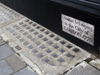
All that is why, in 1776, the City of London owned a conduit miles away, in which the waters of the Tyburn were delivered to the rich burghers in the City, and this stone is still visible on a wall near the Wigmore Street.junction.
At the end of the route for some was the Tyburn Tree at Marble Arch. Condemed prisoners used to be taken in a wagon down the route, and the custom sprang up of people offering them drinks. After the drink, they had to get back "on the wagon" ... after which they would drink no more. Which is where the expression "On the wagon" comes from.
Here is a picture taken in 1957, during excavations. You can see the Tyburn is a trickle at the bottom of the sewer.

A bit longer, more pictures and more involved that the normal London Daily Photo - I hope you enjoyed it.

2 Comments:
Thank you. I like the way the Lane follows the route of the river - the rest of the streets in the area are a grid pattern. You can still see where the land dips as if in a valley. I walked from Baker St to the Thames in the summer following the river as closely as you are able. I didn't spot this though.
I did, thanks! Love all that history.
Post a Comment
<< Home